
The monsoon onset over Kerala marks the commencement of the four-month rainfall season in the country.

The India Meteorological Department (IMD) has predicted above-normal rainfall for the upcoming monsoon season in India (June to September). The cumulative rainfall is estimated to be 105 percent of the long-period average. The IMD has also ruled out the possibility of El Nino conditions during the entire season. The monsoon is crucial for India's agriculture sector, which supports the livelihood of a significant portion of the population and contributes substantially to the country's GDP. However, while the prediction of normal rainfall brings relief, climate change is expected to cause variations in rainfall distribution.

The Southwest Monsoon usually covers the entire country on July 8. The earlier normal date for the monsoon to cover the entire country was July 15.

The southwest monsoon is likely to arrive over Kerala on May 31, a day earlier than its normal onset date, the India Meteorological Department (IMD) said.

Mohapatra said there is a 40 per cent chance of a normal rainfall, 22 per cent above normal, 12 per cent excess and 18 per cent below normal.

The country can expect normal rainfall during the southwest monsoon season as a positive Indian Ocean Dipole (IOD) and a lower snow cover over the northern hemisphere are likely to counter the evolving El Nino conditions, the India meteorological department (IMD) said on Tuesday.

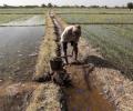
The southwest monsoon has started on a weak note and this has delayed the sowing of kharif crops. Though a cause for concern, the situation hasn't reached a stage where it warrants any panic response. Moreover, according to meteorologists and industry players, monsoon rains will witness a revival in the coming few weeks.

The early onset of the southwest monsoon brought continuous rainfall across southern and eastern India, contributing to this record.

This would be due to early monsoon onset, abundant precipitation in the soil and the government's higher minimum support price (MSP) for farmers, the USDA said in its assessment.
Delhi is preparing for its first artificial rain through cloud seeding to combat air pollution. A trial run was successful, and the first rainfall is expected on October 29 if weather conditions are favorable.
Gross Value Added (GVA) growth in agriculture and allied activities in the first quarter of the 2024-25 financial year (Q1FY25) dipped to 2.7 per cent at constant prices from 4.2 per cent in Q1FY24 due to a drop in output of some crops following heatwave in the main growing months. Low post-monsoon rains, which dried most of the reservoirs in several states across the country, also impacted the production of many crops. At current prices, the growth was estimated at 8.5 per cent as against 4.1 per cent in Q1FY24 due to a spike in food inflation during the April to June months of FY25.
It's still early days, but the southwest monsoon has been nearly 37 per cent 'below normal' in the first seven days (June 1-7) of this month. According to the data furnished by the India Meteorological Department (IMD), between June 1 and June 7, India received 14.5 millimetres (mm) of rainfall, against a 'normal' 23.1 mm. Among places where rains have arrived, monsoon in Kerala in the first seven days has been 48 per cent 'below normal', while in Puducherry, it has been 56 per cent 'above normal'. In Tamil Nadu, rains were 21 per cent 'above normal' between June 1 and June 7.

The southwest monsoon might finally start withdrawing from parts of North-West India over the next three days, signaling the end of its four-month journey over the country that started in June, the India Meteorological Department (IMD) said. However, though the retreat might begin from next week, the rains might not descend quickly, as the met department predicted fresh spells of rains in Vidarbha, Chhattisgarh and east MP on September 21-22 and over Odisha, Coastal areas north Andhra Pradesh and Gangetic West Bengal on September 19-21. "Due to anti-cyclonic flows over northwest India at lower tropospheric levels, dry weather is very likely over west Rajasthan, Punjab, Haryana, Chandigarh and Delhi during the next five days. "Hence conditions are becoming favourable for the withdrawal of Southwest Monsoon from parts of northwest India during next three days," the IMD said.
Weather scientists attribute the early onset of southwest monsoon over Kerala to the influence of the remnants of cyclone Asani that triggered the cross-equatorial flow, a key factor for the seasonal rains.

The four-month monsoon season from June to September accounts for 75 per cent of rainfall in the country.

It rained in the periphery of Delhi -- Aligarh in Uttar Pradesh and Karnal in Haryana -- but clouds hovered over the national capital, without giving any relief from the heat.

The south-west monsoon on Tuesday started withdrawing from parts of south-west Rajasthan and adjoining Kutch in Gujarat, with at least eight states, including rice bowl states of Uttar Pradesh and Bihar reporting deficient rains. It was for the first time since 2016 that the monsoon started withdrawing in the third week of September. "Southwest monsoon has withdrawn from parts of southwest Rajasthan & adjoining Kutch today, against its normal date of withdrawal from southwest Rajasthan of September 17," the India Meteorological Department (IMD) tweeted.
Though early days, meteorologists point towards a neutral La Nina during the initial phase of the four-month monsoon season this year that starts from June. If this holds true, by the time the rains hit the mainland, it could mean there would be one less reason to worry about the prospects of the monsoon this year. Weathermen said making any accurate prediction of how El Nino will behave and what impact it can have on the progress and distribution of rains is difficult to say at this point. A clear picture will emerge around late May or early June.

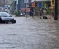
Various parts of Surat were flooded after incessant rainfall in the region. Over 100 mm of rain has blocked roads and led to waterlogging in several low-lying areas.

The India Meteorological Department said the southwest monsoon further advanced into Delhi, Uttar Pradesh, Himachal Pradesh, Jammu and Kashmiri, some parts of Punjab, Haryana and Rajasthan on June 30.
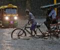
The IMD issued a "Nowcast" warning, forecasting thunderstorms accompanied by lightning and intense spells of rain with gusty winds reaching 50-60 kmph at isolated places in Mumbai in the next three to four hours.

This should augur well for the rabi crops as delayed withdrawal will leave enough moisture in the soil for early sowing.

The southwest monsoon season concluded on Saturday with India receiving 'below-average' cumulative rainfall -- 820 mm compared to the long-period average of 868.6 mm -- in an El Nino year.

Expected to be over 100% of long average period.

After being pummelled by heavy downpours at the start of the week, Mumbai witnessed a brief respite on Tuesday morning, with the island city recording an average rainfall of 106 mm in 24 hours, civic officials said.

The southwest monsoon, a lifeline to millions of farmers of the country, on Saturday set in over Kerala, two days late than earlier forecast. The monsoon has set in over Kerala, IMD Director B P Yadav said.

With the cooling down of heatwaves as the monsoon spreads across the country, power demand has fallen by 12.5 per cent from the start of this month till Monday. Peak power demand of the country had touched a record of 210 Gw last week, mostly due to rising temperatures and opening up of the economy. Compared with the beginning of this month, almost all states have seen a fall in power demand. Punjab, however, is an exception where the power demand on Monday was 17 per cent higher than on June 1.

Conditions are becoming favourable for advance of southwest monsoon over the southern part of Andaman Sea, Nicobar Islands and adjoining southeast Bay of Bengal during May 18-19, the IMD said.

Southwest monsoon has furthered advanced into some parts of south Arabian Sea

Wholesale price inflation (WPI) declined to a 14-month low of 0.39 per cent in May on easing prices of food articles and fuel, and experts said geopolitical tensions could push up prices.

Intense rains lashed Kerala on Sunday, uprooting trees across the state, including one that fell on a moving train in Thrissur and another that caused a fatality in Kozhikode. Houses were damaged, rivers were in spate, and shutters of some dams were raised as the southwest monsoon gained strength. The Indian Meteorological Department (IMD) placed five northern districts - Malappuram, Kozhikode, Wayanad, Kannur, and Kasaragod - under a 'red alert' for the day, predicting extremely heavy rainfall there.

Southwest monsoon hit Kerala on Friday marking the start of the rainy season, four days after its normal onset date.
The Met department had earlier forecast the onset of monsoon over Kerala on May 24, over a week ahead of its scheduled arrival on June 1.
IMD Director General M Mohapatra said there is cyclonic circulation along the Karnataka coast which is hindering the progress of the southwest monsoon.

The India meteorological department said heatwave conditions will persist for at least two more days.

The central and western parts of India, which form the core monsoon zone, may face challenges in coping with the drying effects due to inadequate rainfall early in the season, Skymet Weather said.

Cyclone 'Biparjoy', the first storm brewing in the Arabian Sea this year, has rapidly intensified into a severe cyclonic storm, with meteorologists predicting a 'mild' monsoon onset over Kerala and 'weak' progress beyond southern peninsular under its influence.
The southwest monsoon is likely to hit the Kerala coast around June 1, well within its normal date of arrival, the India Meteorological Department (IMD) said.
Steady progress in June; north and central regions to get good pre-showers

El Nino is often associated with below average warmer, dry weather across Asia Pacific region.